U.S. Senate
See Full Big Line
(D) J. Hickenlooper*
(R) Somebody
80%
20%

Governor
See Full Big Line
(D) Phil Weiser
(D) Joe Neguse
(D) Jena Griswold
60%
60%
40%↓

Att. General
See Full Big Line
(D) M. Dougherty
(D) Alexis King
(D) Brian Mason
40%
40%
30%

Sec. of State
See Full Big Line
(D) A. Gonzalez
(D) George Stern
(R) Sheri Davis
50%↑
40%
30%

State Treasurer
See Full Big Line
(D) Brianna Titone
(R) Kevin Grantham
(D) Jerry DiTullio
60%
30%
20%

CO-01 (Denver)
See Full Big Line
(D) Diana DeGette*
(R) Somebody
90%
2%

CO-02 (Boulder-ish)
See Full Big Line
(D) Joe Neguse*
(R) Somebody
90%
2%

CO-03 (West & Southern CO)
See Full Big Line
(R) Jeff Hurd*
(D) Somebody
80%
40%

CO-04 (Northeast-ish Colorado)
See Full Big Line
(R) Lauren Boebert*
(D) Somebody
90%
10%

CO-05 (Colorado Springs)
See Full Big Line
(R) Jeff Crank*
(D) Somebody
80%
20%

CO-06 (Aurora)
See Full Big Line
(D) Jason Crow*
(R) Somebody
90%
10%

CO-07 (Jefferson County)
See Full Big Line
(D) B. Pettersen*
(R) Somebody
90%
10%

CO-08 (Northern Colo.)
See Full Big Line
(R) Gabe Evans*
(D) Yadira Caraveo
(D) Joe Salazar
50%
40%
40%

State Senate Majority
See Full Big Line
DEMOCRATS
REPUBLICANS
80%
20%

State House Majority
See Full Big Line
DEMOCRATS
REPUBLICANS
95%
5%
 March 08, 2021 02:57 PM UTC
 8 Comments
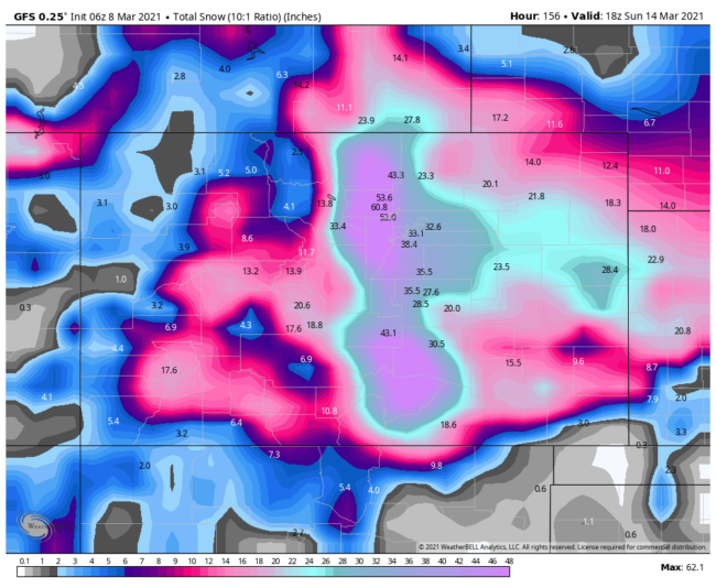
We are so behind in snowpack levels that this is very welcome news. Let it snow !
The GFS (weather model) is an outlier at this point. Other models are running about 2 feet of snow. That's still a big storm, but a far cry from 4 feet.
Whatever.
We have 70+ bottles of wine in our house.
Mr. Barnes: Address???
Weather underground has about 16 total inches for Englewood. I’ll bet significantly under that because the temps will be too warm for snow.
as long as we don't lose power, I am ok with any accumulation…
Perfect way to spend time change weekend! Bring it!
Full freezer. Full bar. Unlimited content on TV. Soft sweat pants and big sweater. …..It's gonna be a good weekend.