
DEMOCRATS
REPUBLICANS
95%
5%

(D) J. Hickenlooper*
(R) Somebody
80%
20%


(D) M. Dougherty
(D) Jena Griswold
60%↑
40%↑


(D) Brianna Titone
(R) Kevin Grantham
(D) Jerry DiTullio
60%↑
30%
20%↓

(D) Diana DeGette*
(R) Somebody
90%
2%

(D) Joe Neguse*
(R) Somebody
90%
2%

(R) Jeff Hurd*
(D) Somebody
80%
40%

(R) Lauren Boebert*
(D) Somebody
90%
10%

(R) Jeff Crank*
(D) Somebody
80%
20%

(D) Jason Crow*
(R) Somebody
90%
10%

(D) B. Pettersen*
(R) Somebody
90%
10%

(R) Gabe Evans*
(D) Manny Rutinel
(D) Yadira Caraveo
45%↓
40%↑
30%

DEMOCRATS
REPUBLICANS
80%
20%

DEMOCRATS
REPUBLICANS
95%
5%

(D) J. Hickenlooper*
(R) Somebody
80%
20%


(D) M. Dougherty
(D) Jena Griswold
60%↑
40%↑


(D) Brianna Titone
(R) Kevin Grantham
(D) Jerry DiTullio
60%↑
30%
20%↓

(D) Diana DeGette*
(R) Somebody
90%
2%

(D) Joe Neguse*
(R) Somebody
90%
2%

(R) Jeff Hurd*
(D) Somebody
80%
40%

(R) Lauren Boebert*
(D) Somebody
90%
10%

(R) Jeff Crank*
(D) Somebody
80%
20%

(D) Jason Crow*
(R) Somebody
90%
10%

(D) B. Pettersen*
(R) Somebody
90%
10%

(R) Gabe Evans*
(D) Manny Rutinel
(D) Yadira Caraveo
45%↓
40%↑
30%

DEMOCRATS
REPUBLICANS
80%
20%

DEMOCRATS
REPUBLICANS
95%
5%
 April 15, 2011 07:17 PM UTC
 116 Comments
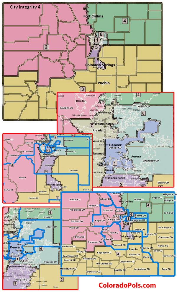
 Today’s the big day for congressional redistricting in Colorado: proposed maps from the Joint Select Committee on Redistricting will be made public on adjournment today. We’ve got a significant amount of embargoed information as well that we’ll be posting once the hold is released.
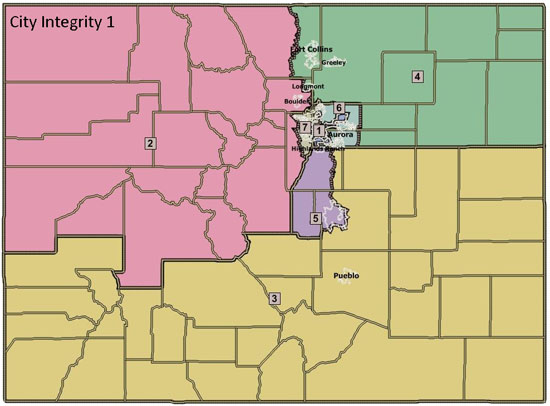
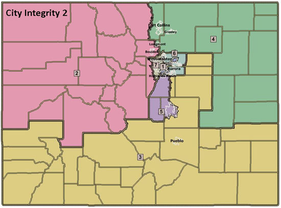
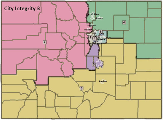
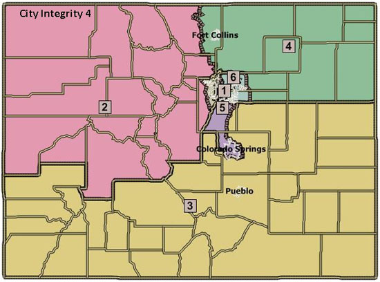
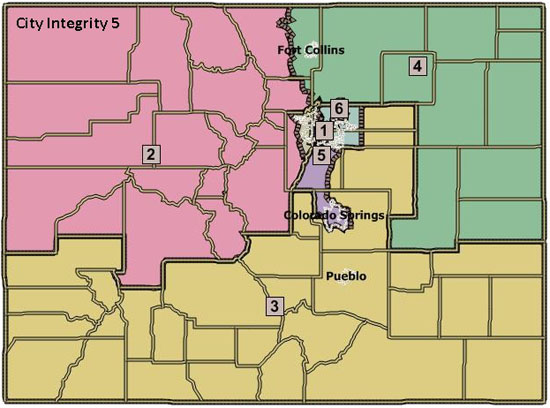
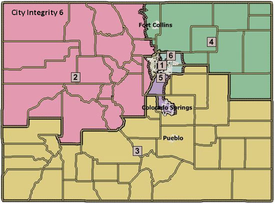
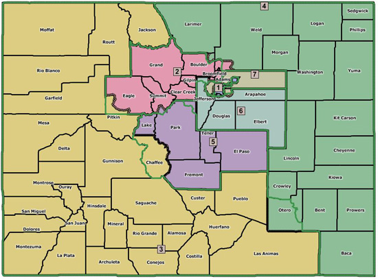
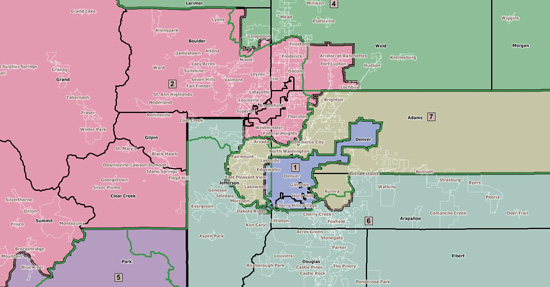
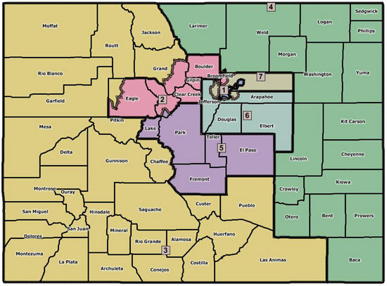
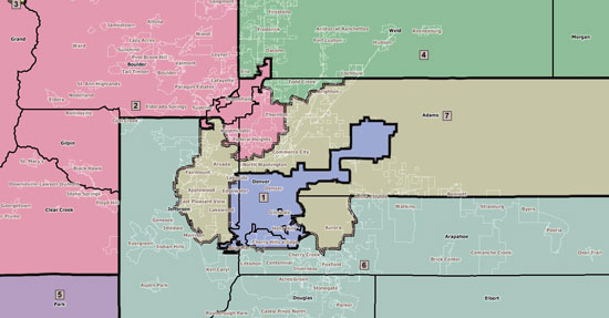
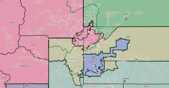
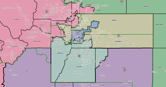
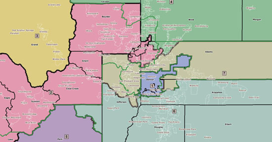
rumor is CD2 might now include westerly Colorado regions including Grand County. Jared Polis representing Grand Junction? He’s proven to be one of the better lawmakers we’ve ever sent to Washington but I have a hard time believing the Repubs in Grand County won’t threaten lawsuit over that one!
Remember how upset the Grand County Repubs were over being included with the Dems of Boulder County? This should be interesting!
Grand is the west side of RMNP and environs.
You mean Mesa County?
District Population Deviation
CO-01 662,039 (56,418)
CO-02 733,805 15,348
CO-03 706,186 (12,271)
CO-04 725,041 6,584
CO-05 725,902 7,445
CO-06 797,813 79,356
CO-07 678,410 (40,047)
Total: 5,029,196
You can see 2 needs to lose some voters, but if its expanding Westwards, 7 is probably expanding into the north suburbs currently in CD-2. It would probably make 2 marginally less democratic but save 7 from having to pick up more conservative voters elsewhere. From this info, the lines in North Denver are probably pretty similar to what we have now. Sounds like it came out of a middle ground plan. If that inference is correct, the lines are not going to change much and I’d bet no incumbents are placed in other districts (atleast on the national district level).
2 may also expand to pick up Longmont, depending on how far north CD-7 is expanding.
I’m most curious what they’re going to do with CD-6. Will we see CD-1 moving into Littleton proper?
though the Dems maps are jokier than the Repubs.
These maps are just the first jabs in a long and ultimately failed negotiation.
Doesn’t everyone expect redistricting to be set again by the courts?
I challenge anyone to look at the Democratic maps, which all are pretty roughly contiguous, with those ridiculously tortured Republican ones.
I’ll say no more, but I’m excited!
I’m just inside a couple of lines, but a shift in any direction just lands me in another amazing person’s district. House or Other Place.
That’s my suck-up for the day.
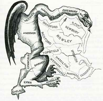
Seriously- you know what goes on back there at Middleton, Danvers and Lynnfield. right?
I choose the oak grove of Ipswich.
cool place.
and you don’t have to live up to your handle all the time…
although I wonder if it’s a bit like looking forward to a car wreck.
Will it be a fender-bender or a 26 car pile up with a jackknifed semi?
If there were more, there would be more maps.
In the Republican Party, the Leadership would have already decided for us. No wonder you guys can’t win elections.
I’m unaffiliated.
The losers party is a state of being, not a registration.
Maybe we don’t like our party to have complete information and descision control. Government by the people and all that.
But I think its just snark. Pretty good snark too.
It’s all straight in my head now.
I have what may be a stupid question, but I’m asking anyway. What happens if, say, CD-6 no longer covers Coffman’s house?
They can either move into the new old district or run against the sitting rep in their new district.
I thought the same thing about the Dem maps. Coffman I think is from somewhere in Highlands Ranch, and if thats true he gets put into Lamborn town.
No, Coffman has lived in Aurora for his entire political career. He’s nowhere near HIghlands Ranch.
… or decide to do something else, or run as a carpetbagger (he only has to live in the same state).
The new Iowa map draws two sitting Congressmen out of their districts. One, a Dem, is right on the edge of the district boundary and could either run from his current house or move to the next town over. The other, a Republican (Rep. King IIRC) is a bit further out of district and will probably have to run in a primary against another current Republican Representative.
you could theoretically have a Rep. who doesn’t live in your district?
Or you’re saying that that could happen anyway? I confess, I hate Congress and rarely learn the laws like I would for the state. I don’t know the residency requirements to run. But if you educate me, I’ll remember forever.
The Constitutional requirements for being a member of the U.S. House are that you have residency in the state you represent.
For a background as to why, it isn’t technically unconstitutional to have representation that isn’t based on districts, so long as whatever solution is used provides equal representation (e.g. s proportional representation system); such alternate solutions are IIRC currently against Federal law, but not unconstitutional.
Whether your Representative serves you if he’s redistricted out of your district is I guess a matter of debate. The maps have no real effect until the next election regardless – your Congressperson is elected to serve a 2 year term and their job doesn’t end just because the map is changed.
Coffman could run for Congress in Ft. Collins and still live in the South Metro area. Remember, when Bob Beauprez ran and won in CD-7 in 2002, he lived in Louisville (though he bought a place in the district, he didn’t live there.)
It’s scary.
(Thanks for the info!)
Of course, it’s actually the Republicans who move his house out of his district, as you’ve pointed out.
But why is Coffman getting all bent out of shape?
Seems as plausible as any other explanation.
against the Democrats. Nothing more, nothing less. He didn’t think anyone would call him on his mendacity and “the Democrats are screwing Coffman” would be the impression that sticks.
All of the Dem-proposed maps bring Greenwood Village into CD1. From a population standpoint, that move is a no brainer, I did it on my map too.
Otherwise you have to divide a city to get CD1 to the population it has to be. The GOP maps alternate between dividing Lakewood or dividing Aurora. Notably, they dividing of Aurora model puts Morgan Carroll in CD1. Can’t see that one passing.
according to the U.S. Constitution. Up until the ’60s, it was common for states to have ‘at-large’ members of Congress, even if there was a multi-member delegation.
Splitting the western slope would be a travesty.
CPols has been trying to downplay its status as a community of interest for a while now, and now I see why.
And why is rearranging the map in the most drastic fashion a good thing (for anyone other than democrats)? Isn’t continuity in representation something laudable?
Technically, you’re not even supposed to consider the previous boundaries during redistricting — the idea is to draw new lines that reflect population shifts.
What do you mean by “fair representation”? That seems like a nebulous concept that people use to justify political outcomes.
I know you dead guvs have a hard time recognizing this, but the western slope is a community of interest that deserves to be preserved as much as possible. The unique geography of Colorado (and thus the resources and culture that it exhibits) should not be thrown by the wayside to make representation more “fair” (cough-cough more Dem friendly districts).
Continuity of representation – i.e. having the same representative between redistricting – is not supposed to be a consideration, though it usually winds up being one (see the Republican maps for examples…).
I’ll argue the community of interest thing below where more appropriate.
I’m in CD3 now and in all the new maps. Really, I would say our community of interest is just as strong with the San Luis Valley and Pueblo as with the Steamboat Springs area. I don’t understand putting Eagle into a different district. If it’s the mountains / western slope, it seems Eagle should be in CD3. I smell politics is the answer.
On the Dem maps, I hate having Arapahoe or Adams being part of CD3. It’s a rural district (as a community of interest). I think if you can reduce the sheer size of the district it would be a good thing.
But one that needs to be balanced against the thousand others that the Joint Select Committee heard while touring the state.
As an FYI, the Western Slope community of interest is split in the the current congressional configuration. 10 years ago it was decided that that while the Western Slope was, and continues to be a community of interest, the expansion of towns along the I-70 corridor took priority. In these new maps, which are not perfect, this logic continues by making the mountainous portions of I-70 the center of the district.
Actually, neither the Republican nor Democratic maps keep the Western Slope whole.
They’re both DOA as far as I’m concerned.
We have always said the same thing about the Western Slope — it is no longer that important in statewide elections because there just aren’t enough voters living in the area. It’s not our opinion of the community — it’s just pure numbers. More than 85% of voters in Colorado live along the Front Range, which means there aren’t enough people on the Western Slope to sway an election unless 90% of them vote the same way (which would never happen).
I agree that the population shifts have made the western slope less relevant in STATE elections, but that isn’t really what we are discussing here.
This is an insular, geographically distinct group that deserves to have unified representation in Congress.
There are a lot of ‘geographically distinct’ regions in Colorado, and pretty much all of the are part of multiple regions. It’s not a series of lines, it’s a spectrum.
So in the case of the Western slope, the simple reality is that it doesn’t have enough voters remain whole any more. Boulder is closer to the mountain towns that it would be to, say, the high plains.
Similarly, Pueblo is closer to the San Luis Valley than the Valley is to Grand Junction, or than Pueblo is to the Springs. And that is basically why the slope is getting split. There are geographic distinctions among the counties (especially north/south) and largely speaking those are going to outweigh the amorphous notions you’re touting.
If the slope had more people, it would be a district with it’s own distinct representation. But that’s not the case. And the argument you’re making is for government representation based on sentiment instead of substance, which sounds nice in platitudes but lacks logical coherency.
Continuity in representation isn’t a high priority. Not splitting geopolitical areas or communities of interest is the highest priority by state rules.
I think I liked Dan’s map better, but there’s something to be said for the Dem maps, too. Like Dan’s maps, they keep cities intact, and counties too, mostly. And they do follow communities of interest if you think outside the box of the last 10 years.
I think calling the West Slope a unified community is a mistake in 2011. Grand Junction and Ouray have little in common with each other aside from being west of the Divide. They have different interests even when it comes to water.
I guess this is just a factual disagreement then. I would argue that the very fact that these towns are west of the divide is an incredibly powerful factor for comm of interest.
Communities west of the Divide all have generically common water interests, since all of the water eventually flows out of the area. And they are a community of interest because they often get ignored by the Front Range.
But they also have divergent interests – development, ranching, O&G, skiing and ecotourism… There’s no one solution that will fit them. Dan Willis tried, and even his map can’t keep the area together.
So the best you can try is to put similar (contiguous) communities together, then aggregate those communities until the population comes out right for a district. And everyone’s got a different idea on how to do that.
I don’t think the Dem maps are perfect, and yes it’s mostly because of the split of the West Slope and Plains. I think the Republican maps perpetuate some problems (from the current map) that are even more undesirable, i.e. the splitting of towns and cities.
If we are going to be honest we should admit there are ways that the eastern plains and the western slope can remain intact (for the most part) with minimal splitting of towns/counties. But this may not be the most politically palatable to either side.
But I would still argue that the western slope is almost the paradigm for a community of interest. To illustrate, I will use your examples of the western slopes divergent interests: “development, ranching, O&G, skiing and ecotourism.” It is clear that these interests are all related at least tangentially to the western slope’s unique geography and commerce. Those “divergent” interests are more similar to each other than many of the interests which exist along the front range including heavy/light industry, urban/suburban development, tech corridors, banking, heavy infrastructure. To put it simply, Ranching and skiing are both related to rural interests whereas heavy industry and banking are both related to urban interests.
And I know you mentioned it, but the common water interest of the western slope is almost reason enough to keep it intact. The divergence of interests among the front range and the western slope in relation to water is absolutely titanic.
are just as prevalent on the eastern plains. By that measure, Garfield and Weld counties have more in common than some of the West Slope counties do with each other. And there are plenty of West Slope counties without any skiing, so that’s not what ties them together. If it’s just water, then, well, aren’t there clubs and so forth that handle that? It seems a slim thing to hang an entire congressional district on.
has been the standard used by courts now for 30 years.
The fact is, Colorado doesn’t look much like it did 30 years ago, community wise.
I would argue that the Plains make for a strong community of interest, but the West Slope is not to my mind at all monolithic.
Let me spell it out for you: w-a-t-e-r.
Colorado has been blessed over the years to have those kind of politicians that clearly understand the importance of your friend and mine, Mr. H2O:
Fuck it’s so bad. I would have plagiarized too!
On a serious note, what we need to do is eliminate grass lawns across the state. Lawns are nuts in a climate like this and people have them mainly because that’s the default decision (myself included).
And everybody should ride ponies! Wowee!
(GD f**king fascist HOA) . . . having a lawn isn’t a choice, it’s a requirement.
(I guess the biddies that run things on our board can’t stand the thought of the guys running around on weekends unbound by yard equipment seven months of the year.)
The thing that makes Mesa and San Juan counties part of a single community of interest is that their water flows out of state and is in high demand. That means it’s just like every other county in the state, most especially counties in the mountains on either side of the divide – which makes the Dem map look rather honest. Thanks for clearing that up for me. Now I’m ready to accept the Dem map as-is.
I’ll lower the sarcasm just a bit to admit that Aurora, Denver, and the other big cities along the Front Range don’t generally have their water in demand elsewhere and are instead demanding it. Of course, they generally have their own districts regardless of how you redraw the map.
But every river in this state is allocated in part to out-of-state interests, and most of what’s left is in demand within the Front Range metro areas. In that respect, the plains, central mountains, Arkansas River valley, and west slope are all one big community of interest.
Beyond that generality though, the communities in the Yampa, Colorado, Rio Grande, San Juan, Arkansas, Platte, and Purgatoire river systems don’t IMHO share a de facto community of interest – a four corners approach to redistricting serves the needs of the “water” community of interest as well as any other in that respect, and in some ways might strengthen the community’s representation.
Water is very important for Colorado. For those that care about water, you know that water flowing west of the Continental Divide flows into 3 different water basins within Colorado.
Oftentimes, those three different water basins on the West Slope differ in their priorities. Those differences have resulted in prolonged litigation pitting residents of one basin against residents in adjoining basins.
If you are new to Colorado, or if you only spend time in Denver, I can understand why you think all of the West Slope is the same when it comes to water. But if you spend time in the West Slope, you quickly learn the differences between Craig and Montrose and Steamboat and Durango. While all of these cities are on the West Slope, they are worlds apart.
“spending time” on the West Slope?
exhibited good behavior?
Most folks on this site don’t realize that, but here in the home of Wayne Aspinall, we get a daily reminder.
The western slope is currently split between CD2 and CD3. Eagle, Summit and Grand are in a different district than the rest of the Western Slope. These districts were selected by the Court.
Obviously, the Western Slope whole has not been the standard for at least the most recent decade.
That is the feed back I have gotten so far.
Grand, according to the Redistricting Committee has expressed a desire to be CD3.
There is also an argument to put Eagle, Summit and Lake together in whatever district they are in. The thought is that most of the employees who work in Eagle/Summit, live in Lake. Not sure of the truth to that, bt if true, it would make sense they are a combined community
Lake County is VERY MUCH considered to be part of Eagle and Summit both – keeping them all together would be ideal!
When the committee met in Pueblo there were strong inputs on making the Arkansas Valley one community of interest. At one of the other southern colorado meetings, Fremont County indicated they wanted out of the 5th.
at least the Democrats and non-extreme middle of the roaders would like out. With a change, the Honorable Congressman would have to find some place besides Canon City to tell an audience member to “shut up.”
Grand, Summit & Eagle are in CD2. Unless we’re going to start talking “real” Western Slope. And as Pols reminded us yesterday, districts used to divided between northern and southern Colorado.
…are pretty radical.
CO-02 would have a bit of a different character, definitely more competitive with southwest Jeffco and Mesa Counties included; CO-06 would definitely change character as well. CO-05 would become even more overwhelmingly Republican under the Dem proposals, but really the proposed district has more in common with itself than the current boundaries. I think I like the shape of the map, especially the first proposal; it does an okay job of grouping communities and unwinds the spaghetti that is the current CO-07.
I’m having trouble reading CD4. Has Estes Park been moved to CD2?
Looks like whoever drew the map boundaries in CO-02 pretty much decided to follow the line of the foothills, plus or minus – and then threw in Boulder city.
being accepted I will once again believe in God.
You know you like Cory Gardner – admit it.
God owes me. Bigtime.
I’ve been “left behind” in your Rapture moment!
If this comes to fruition, my guest bedroom is all yours.
Both D’s and R’s introduced 6 maps. Each set followed a theme.
The Republican theme was take the current map and make adjustments for population only.
The Democrats theme was to split the state north from south rather than the current east from wesst and the northern half would be then also split into half west, on one side, east on the other. These are illustrated in the images at top of thread.
I hate both ideas.
I actuially get where the GOP is going better. They latch on to one part of the redistricting criteria (maintain the current map to the extent possible) but this ignores the other (and more pressing in my mind) of keeping municipalities/counties/communities of interest together to the extent possible.
Each of their maps extended CD1 into either Jeffco (to Wadsworth) or Aurora (to Peoria it looks like on their maps), and keeps CD7 close to same adding more Jeffo to it. They do the good thing of putting Chaffee in CD3, but take little nicks out of several other rural counties to make numbers balance. Some combine Otero, sone don’t.
The Dems’ are simply a mess, for several reasons. For as strongly as I argue to keep Denver whole, I also argue the same for El Paso County. Each of their maps is based on Colorado Springs being severed from most of El Passo County and added to western Douglas County.
The whole concept of a southern district, in my opinion (for what that is worth) will not hold up in court because it forces splits of the Western Slope and the Eastern Plains, two widely recognized communities of interest.
From a partisan standpoint, the Dems seem to trying for more competitive seats, but that is not one of the criteria of redistricting. However, I do find the concept of competitive seats appealing for several reasons.
At least the GOP are unabashedly creating stronger possibilities for themselves.
Having said all of that, the two sides have carved out the outer ranges of the discussion. Now they have to see if they can work their way back into a more common center ground.
that the “middle ground” is a completely different map – like yours?
I do have to wonder along with you why the Dems decided to redraw this way. I don’t get the reasoning behind it, unless competitiveness was their driving goal.
Not necessarily mine.
There are several ways to draw a map that takes elements of both ideals and form a compromise composite.
That’s a redistricting criteria? Whose?
That full subsection:
(b) May, without weight to any factor, utilize factors including but not limited to:
(I) The preservation of political subdivisions such as counties, cities, and towns. When county, city, or town boundaries are changed, adjustments, if any, in districts shall be as prescribed by law.
(II) The preservation of communities of interest, including ethnic, cultural, economic, trade area, geographic, and demographic factors.
(III) The compactness of each congressional district; and
(IV) The minimization of disruption of prior district lines.
Of course, it does say “may” and”not “shall” so calling them “criteria” may not be precise, but it is the yardstick they use.
the Dem maps passing muster if that’s in the state law. I’m assuming that’s the legislation that passed recently, so the wild shifts in the ’70s and ’80s weren’t encouraged to take that into account.
Thanks for pointing to that, Dan.
This is not a state law that pertains to legislative redrawing of congressional districts; it only pertains to maps drawn by Courts should the legislature fail. Read the full statute, the correct citation is 2-1-201.
http://www.michie.com/colorado…
You’re correct that this seems to be the factor Republicans are most interested in utilizing, but it’s not how redistricting, by any principle including federal law, is supposed to work. Drawing fair and equal districts is more important than prior district lines.
From a logical standpoint, it’s much easier to convince someone that city and county boundaries should be respected more than an existing congressional district boundary. Those communities are what people identify with, not what congressional district they’re in.
In short, we’ll concede that this is a factor they can consider, but they’re in no way obligated to consider it. What’s more, the process as it’s supposed to work works pretty strongly against this consideration. We appreciate you pulling statute to clarify this, including the fact that it’s not binding.
In terms of the two different strategic approaches you were talking about above, we can’t really speak to the Democrats’, and from a purely partisan point of view not going for maximum advantage is a little curious. It could be based on an assumption that Democrats will do better with independents long-term, so Colorado’s version of “competitiveness” works to their advantage. Republicans, as you help demonstrate with your comments, have both an simpler pitch for their plan, and clearer partisan advantage sought.
Democrats might be able to get closer to their version, in the legislature or more likely in court, if they can turn that simplistic yet partisan approach against Republicans. We agree they have more messaging work to do than Republicans, because theirs is the bigger proposed change, but there is also a value in throwing the debate wide open–which they’ve definitely done.
Avoiding racial splitting is higher in importance than these four subsection factors. After the constitutional requirements are met, it is interesting that the law gives equal rather than preferential weighting to all of them.
If you can’t meet all four factors, but they are equal in importance, then the map makers won’t get into trouble as long as most of them are mostly met… whatever “most” means.
Nobody has commented that the South of Colorado, from the San Luis Valley into the Eastern Plains, has higher hispanic population. This hispanic heritage goes back a few centuries, so you could argue that racial requirements of the voting rights act would prefer a Southern district.
Competitiveness isn’t listed as a criterion, but I prefer a map with a higher number of competitive seats over one that strongly guards one of the inmates.
The Voting Rights Act trumps.
A map is not going to be a problem with substantial district changes if it does a good job with fairly representing communities. If one can accept that, Dems can win the public with more competitive districts.
Dan,
This section (actually 2-1-201), are the neutral criteria for COURT drawn plans — hence the title of the code section, “Neutral criteria for judicial determinations of congressional districts.”
Similar criteria for plans drawn by the legislature are non-existent in statute.
Even if you were to look at the criteria above, the court may utilize those factors, but it is not required to, nor is the court limited to those factors.
there is no guidance in statute, so the only guidancve given to legislators is through court actions.
Federal law gives a little bit of help with the Voting Rights Act, but in Colorado ist would actually be difficult to draw a map that violates that. It come more to bear in other states.
The legislature knows full well any map they pass will face a judicial challenge. They simply can’t please all of the people all of the time. So they have to look at their plans with the same eyes that a judge will look at them with later.
The statute, 2-1-201, only applies to a judge if and when the legislature fails to adopt a map.
The statute, 2-1-201, does not apply to maps drawn by the legislature. If the legislature adopts a map, signed by the governor, then the standard a court applies is whether the map is unconstitutional. Whether a map is unconstitutional is based on whether: (a) the map equalizes population; and (b) whether the map violates the VRA. As redistricting is a statutory adoption, like any other statute, there are no other factors, except constitutionality, involved in a judicial analysis as a function of law.
2-1-102. Neutral criteria for judicial determinations of congressional districts.
(1) In determining whether one or more of the congressional districts established in section 2-1-101 are lawful and in adopting or enforcing any change to any such district, courts:
(a) Shall utilize the following factors:
(I) A good faith effort to achieve precise mathematical population equality between districts, justifying each variance, no matter how small, as required by the constitution of the United States. Each district shall consist of contiguous whole general election precincts. Districts shall not overlap.
(II) Compliance with the federal “Voting Rights Act of 1965”, in particular 42 U.S.C. sec. 1973; and
(b) May, without weight to any factor, utilize factors including but not limited to:
(I) The preservation of political subdivisions such as counties, cities, and towns. When county, city, or town boundaries are changed, adjustments, if any, in districts shall be as prescribed by law.
(II) The preservation of communities of interest, including ethnic, cultural, economic, trade area, geographic, and demographic factors.
(III) The compactness of each congressional district; and
(IV) The minimization of disruption of prior district lines.
Back when everyone of the Western slope was involved in mineral extraction and everyone on the Eastern plains was a farmer you had a point. But the economies, of each have become a lot more diverse – especially the Western slope.
I think a high tech company in Grand Junction, and all of it’s employees, families, etc. have a lot stronger community of interest with the high tech companies in Boulder than they do with the people working for the O&G companies.
Cities & Counties have a community of interest because they suck at the federal teat. But to say most people on the Western slope have common interests in D.C. that differ substantially from people elsewhere in the state – I don’t see that.
you have no fucking clue.
in his first paragraph, but after that he loses me.
Why not point out that a micro brewer in Durango and all its employees, their families, etc., have a stronger community of interest with a micro brewer in Fort Collins than they do with someone who works as an auto mechanic?
Defining communities of interest based on the area’s top lobbying topic in D.C. seems to miss the point.
Granted, you can’t draw lines for this. But one of the most important things we get from our reps is attention to issues that matter to the industries in their district. For example, education is key in my industry, not so much for people running gas rigs where drilling permits & regulations probably come first.
I think it’s good that reps have a range of industries as that helps ameliorate the degree to which they’re owned by an industry. But I do think I have more common interests with people who work at high tech industries in Grand Junction than I do neighbors who own a construction supply company – at least in terms of what I want from a representative (state or federal).
and hire a lobbyist.
David, I understand you’re making a larger point here, but it sounds like you’re wearing the narrowest blinders imaginable. How about a special “high tech” district stretching from Greenwood Village up I-25 to LoDo, then up US 36 to Boulder, then across some backroads to Fort Collins and then shooting out to Grand Junction?
that someone has the sense to shoot such a proposal down quickly, and then find a nice safe place for whoever proposes it in seriousness.
However, David has discerned a point through his tech-shaded glasses. The Plains are a community of interest specifically because they are linked by an industry which has shaped their way of life. Eagle, Grand and Summit counties are currently in CO-02 in part because their predominant industries have linked them in some way to the issues in the rest of CO-02.
When trying to map out Congressional districts under the current allocation of some 727,366 citizens per district, there is no way to either (a) contain all citizens in a community of interest within a single district, or (b) restrict a district to a single community of interest. How you decide which communities of interest to group together, and where and when to split them, is bound to piss off some people regardless.
I’m not proposing a high-tech district – that would not serve anyone well. But by the same token I don’t think one defined by water makes sense either.
Then everyone will know who the ‘MicroBrew’ rep is (like they could afford one!) I mean the InBev Congressman.
While the politicians and economics of the Western Slope are changing and are more diverse than a few years ago, one thing unites us: although we might enjoy a trip to Denver for a game, a cheaper flight, or a good meal–most of us are quite glad to be back in the pretty part of the state. There is a ‘West Slope’ identity of sorts–apart from the politics even and the lil abner stereotypes (“back when everyone was working in mining…” maybe they were a community of interest…guess what, we were never all working in mining–we may have been dependent on that economy, but we were growing food for mines, building water projects to water the farms, raising cows, etc. Tourism has always been a fixture–many of the railroads built lodges and facilities around the backcountry specifically to lure folks out here).
The ‘community of interest; is more than being joined in a common occupation, as a Boulder and a Montrose Barista.
Your use of reasoned logic, numerous pertinent facts, and scintillating prose makes it impossible to refute your conclusion. Well done sir.
more words than are necessary to define the problem?
when all of the West Slope was involved in a single industry. Agriculture, mining, recreation, etc. have always existed in the district, and they still are here today. Even “high tech,” such as it is on the Western Slope, exists throughout the district.
But the one most unifying issue on the Western Slope is — and always has been — water. That’s an extremely powerful community of interest in Colorado, and it is a key issue that helped get the old 3rd district (which stretched west to east from Grand Junction to Sterling) changed to its current north-south configuration.
Good luck to the Dems who seem to want to return to those old days. They’re going to have to make a hell of an argument when this ends up in court. And you know that’s where it will go eventually.
Polis at Grand Junction. Sherman at Atlanta.
It’s payback time.
I am just kidding. Jared Polis is a much better and fairer minded person than I am, and it’s a good fucking thing for Janet Rowland.
I am appalled that the Republicans are advocating for safe seats for both parties. I listened online to all of the public congressional hearings and while the testimony was varied, there was one constant: we want competitive districts.
It doesn’t matter who proposes the map; look at the voter registration and create compact, competitive districts.
It is just the nature of the clumping of population.
Any district including Denver is going to be Dem. Any disitrict including Colorado Springs is going to GOP.
About the most competitive seats we can muster would be 4, but then that leave one party with 2 safe districs vs. the other one with only 1. The more balanced way to handle it is to have 4 safe districts, 2 for each party and 3 truly competitive ones.
I want 2 safe seats (because there’s no way around that) and 5 competitive seats. They don’t have to be dead even, but close enough that a lousy incumbent will lose to a strong competitor.
The headline says it all…
http://www.gjsentinel.com/news…
I’m surprised it’s not in bigger type…you know, like when Pearl Harbor was bombed.
Apparently the problem is that they don’t have farms and tourism back that ways…
Now, I’m a West Sloper with an appropriate outsized sense of our importance, with 15% of the people and ‘more oil than God’ or something according to my congressman…but I do think some geographic diversity in our representation is good…so this struck me.
But, at the end of the day what has the WS GOP upset is that their enabling of the fleecing of our resources might be hampered.
By ‘protecting water’ dear readers, Ms. Laura probably means impounding it where it occurs naturally and letting oil and gas companies dump massive amounts of it onto the ground where it doesn’t.
In any case, I remain unaware of where prairie dogs halted a water protection project; or where water protection was thwarted by the little flea-ridden cuties; but I also remain unaware of Rep. Bradford ever saying anything remotely sensible, so there.
That the parts of Adams County that are in CD 3 on those maps are pretty darn rural. It’s not like they threw in Thornton or something.
More data on proposed maps here: http://www.colorado.gov/cs/Sat…
Still hard to tell some of the lines in the metro area.
Every district will be touching the Denver Metro area? So Denver Metro will influence all of our Representatives? Can you say “gerrymandered” children? I knew you could.
The “spoke” model does seem to unnecessarily involve metro Denver in too many districts, though it doesn’t appear some of the Dem maps get that close to the actual metro area in the 3rd and 4th districts.
For what it is worth…
1. DEMOCRATIC KUDOS & GOP SHAME –
First off, the Democrats have put together some terrific maps – my worst criticism would be that it seems odd to combine Grand Junction with Boulder, but outside of that, the Democratic maps are excellent
2. WATER! –
The Southern part of Colorado, particularly Pueblo, the San Luis Valley, and the Arkansas River, should be UNITED, as they all carry the interest of water (water!) – the current CD3 map, while uniting the Western Slope water interests with Pueblo, leaves the Arkansas River in bad shape, representation-wise
And yes, Grand Junction and the northern parts of the Western Slope are home to major reservoirs of water, but the footprint of the Democratic proposed CD2 encompasses enough of the Western Slope, that it would effectively force the Congressman (in this case, Jared Polis) to be sensitive towards those issues – overall, the Democratic maps are a slam dunk for water! (WATER!)
3. RURAL vs METRO –
I believe CD4 is well-crafted, as like CD2, it has enough rural counties to force sensitivity out of whomever represents it — with that in mind, being that I grew up in rural Colorado, I think the Democratic maps send 3 Congressman with strong sensitivities towards ‘rural’ Colorado to Congress, rather than the GOP maps, which in my opinion, risk giving rural Colorado only 2 Congressional voices (and again, Jared Polis does an EXCELLENT job of representing the Western Slope, but such guarantees are not in place, in case there was a successor to the good Congressman Polis)
4. GOP RURAL EXPLOITATION –
It wasn’t until looking at these maps, that I realized how much the GOP seems to despise rural Colorado
In an effort to create the GOP strongholds of CD5 and CD6, rural counties are treated like garnish on a main course plate, haphazardly attached to El Paso and Douglas counties, where their rural issues are likely to be overshadowed by the metro issues bred by El Paso and Douglas
Let me make this clear – I love El Paso county (I basically grew up there) and I feel the same about Douglas – but if the GOP maps are accepted, they are accepted to the detriment of all the rural communities that are being forcibly attached to Douglas and El Paso, simply for the sake of maintaining two GOP strongholds
And after running for statewide office in Colorado, I can confirm that Douglas County and Colorado Springs have QUITE A LOT in common – as a matter of fact, you will often see CSpringers at the political events in Douglas and vice-versa
Kudos to the Democrats for combining Douglas to Colorado Springs – it is the right thing to do and it will further guarantee that rural Colorado has a voice
5. PUEBLO –
Another town I proudly grew up in (lol)
But honestly – there needs to be more love for Pueblo – Pueblo’s steel mills basically BUILT what is Colorado today, yet with the exploitations of gerrymandering, Pueblo has lacked a voice in Congress
While Grand Junction and Pueblo do share water interests in common, within the current CD3 district, the oil and gas interests emanating out of Grand Junction, compared to the labor interests of Pueblo, pit both these great cities against each other, in the worst way
As one of the largest cities outside of Denver, Pueblo SHOULD anchor a Congressional district in Colorado, and appropriately, under the Democratic map, it would anchor the WATER district – bravo to the Democrats!
And of note, CD2 basically becomes Senate District 8, but with Boulder (lol) – it’s a slam dunk because we should keep Colorado’s oil interests in one district, without having to combine it with the water interests in the south – again, it is weird to have Grand Junction with Boulder (and man, Jared, you better set aside money for gas!), but nonetheless, no map can be perfect and the Democrats have done much better than the GOP
6. EASTERN PLAINS –
I don’t mind that the Democratic maps have divided the Eastern Plains – seriously, the Eastern Plains are HARD to travel and I think the Democratic maps give us two Congressman now who look out for the Eastern Plains, rather than just one
Of note – we MUST have Congressmen sent to Wash DC who are sensitive to the Eastern Plains, as various railroad lobbyists in Wash DC are pushing to move federal train tracks away from Downtown Denver and move them right into the heart of the Eastern Plains, effectively destroying many communities there and agricultural lands
As the coming years approach, we need to have as many Congressman as possible, in our delegation, who are ready to FIGHT for our Eastern Plains and the Democratic maps accomplish that!
7. MIKE COFFMAN & DOUG LAMBORN –
Fearless prediction here – if the Democrat map is adopted (which it probably will be, as the House will not agree on a map, thus sent to the Courts… we all know how they lean…) I think it is likely that Lamborn and Coffman are now both in CD5
Again – fearless prediction – Mike Coffman will stay in Douglas and primary Lamborn and WIN
In my many travels to Colorado Springs… and I truly mean this… I have yet to find someone who really lives and dies for Doug Lamborn
I have found PLENTY of CSpringers, on the other hand, who LIVE AND DIE for Coffman, on the basis of his fine military service and his conservative stances
Doug Lamborn is finished – Mike Coffman will go on to represent the most conservative seat in America (which is a good thing – Colorado will continue to have strong, polarizing voices, which only enhance the debate) and Doug Lamborn will return home to Colorado Springs – everyone wins! (lol)
8. MORGAN CARROLL –
God Bless the way CD6 is carved out – and I promise you all here – if/when Morgan Carroll runs for Congress, I will find a way to spend time volunteering and contributing – I WANT MORGAN CARROLL IN CONGRESS
While Democrat and Republican legislators were taking oodles of money from private prison builders (hello Cornell Group!), and at the same time, passing bills to build these private prisons, as well as not take down drug laws or reduce 3 strikes, it was MORGAN CARROLL who VALIANTLY fought, on the basis of principle, against this corruption, by noting that we NEED TO CHANGE our criminal regulations – and she did it, KNOWING, that the prison industry could do everything possible to destroy her career
That, my friends – that is a hero
Mark these words – Morgan Carroll is going to be one of the FINEST Congresswomen to have ever served – and Colorado will be proud to send her
Standing in Morgan Carroll’s way, I’m sure, will be Ryan Frazier, who will be retreaded to run against her
Let us not forget – Ryan Frazier, despite a Republican wave in 2010, got LESS VOTES than John Larue (spelling?) the Republican CD7 candidate in 2008, who ran against a Democratic wave
Ryan Frazier for CD6? If he can’t beat EddieP in 2010, he has no chance against my girl, Morgan!
This seat is Morgan’s and I’ll be there to make sure of it!
9. HASAN RUMORS –
What’s a post without Ali Hasan rumors???
I heard through some grapevines that, while Scott Tipton pressed hard to have the GOP throw Summit and Eagle into CD3, there was a counter vibe saying that I would run for CD3, against Tipton, had my home counties of Eagle, Summit, and Pueblo all been put into one district – in turn, such rumors squashed any GOP plans of such a move, leaving Summit and Eagle, in all maps, with CD2
Of note, the television ads I ran, in running for State Treasurer, have given me NAME ID in the 60’s to 70’s all over Colorado, but most especially, in Grand Junction, where we rocked the local television ad-buys!
With that said – I adore Colorado, but I have no intention of running for Congress – and if such rumors helped keep Eagle and Summit in CD2 with Jared Polis, then I’m a happy man and those ad-buys on Grand Junction television were more than worth it!
10. SHAKEUPS –
Scott Tipton is a well meaning man and wants the best for Colorado – that said – he’s not going to survive the Democratic CD3
Jared Polis will definitely triumph in CD2, as Garfield, Routt, Eagle and Summit are Democratic – Boulder will outweigh Grand Junction – nonetheless – Jared will have more work, but Grand Junction is LUCKY to (possibly) have him as a Congressman
I have no idea how to read Cory Gardner’s chances? He is hurt by the fact that much of the Republican Eastern Plains is cut off, but judging by the map, I can’t tell whether more Democrats have been effectively added? Cory Gardner is a good guy and hard working – he won’t go down without a big fight
Of course, Doug Lamborn sent to retirement – Mike Coffman moves on, into Congress
Under the Democratic map, as well, it seems that we could really have, only one, guaranteed GOP seat (CD5), with five guaranteed Democratic seats, along with one tossup – CD4 — pretty darn good job, on the part of the Democrats, but more importantly, as demonstrated, the Democratic maps MAKE SENSE
Alright – that’s my analysis – hope it helps and enjoy (and as always – sorry to weigh in late – again, I’m one hour behind you guys here in California – lol)
I LOVE YOU ALL!
Muhammad Miguel Ali Hasan
Forgot to mention – if I’m not mistaken, I believe the Democratic maps keep the mouth of The Big Thompson project in CD4, not CD2 – this is vitally important, as with CD2 acquiring so much more of the Western Slope, having the Big Thompson Project in CD2 would make for a catastrophic conflict – I believe all Democratic maps make this seperation and that’s a good thing