DEMOCRATS
REPUBLICANS
95%
5%

(D) J. Hickenlooper*
(R) Somebody
80%
20%


(D) M. Dougherty
(D) Jena Griswold
60%↑
40%↑


(D) Brianna Titone
(D) Jeff Bridges
(R) Kevin Grantham
40%
40%
30%

(D) Diana DeGette*
(R) Somebody
90%
2%

(D) Joe Neguse*
(R) Somebody
90%
2%

(R) Jeff Hurd*
(D) Somebody
80%
40%

(R) Lauren Boebert*
(D) Somebody
90%
10%

(R) Jeff Crank*
(D) Somebody
80%
20%

(D) Jason Crow*
(R) Somebody
90%
10%

(D) B. Pettersen*
(R) Somebody
90%
10%

(R) Gabe Evans*
(D) Manny Rutinel
(D) Yadira Caraveo
45%↓
40%↑
30%

DEMOCRATS
REPUBLICANS
80%
20%

DEMOCRATS
REPUBLICANS
95%
5%

(D) J. Hickenlooper*
(R) Somebody
80%
20%


(D) M. Dougherty
(D) Jena Griswold
60%↑
40%↑


(D) Brianna Titone
(D) Jeff Bridges
(R) Kevin Grantham
40%
40%
30%

(D) Diana DeGette*
(R) Somebody
90%
2%

(D) Joe Neguse*
(R) Somebody
90%
2%

(R) Jeff Hurd*
(D) Somebody
80%
40%

(R) Lauren Boebert*
(D) Somebody
90%
10%

(R) Jeff Crank*
(D) Somebody
80%
20%

(D) Jason Crow*
(R) Somebody
90%
10%

(D) B. Pettersen*
(R) Somebody
90%
10%

(R) Gabe Evans*
(D) Manny Rutinel
(D) Yadira Caraveo
45%↓
40%↑
30%

DEMOCRATS
REPUBLICANS
80%
20%

DEMOCRATS
REPUBLICANS
95%
5%
 June 11, 2021 11:24 AM UTC
 14 Comments

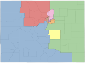
It looks like quite a few counties are split up by this plan; I'm not sure that is kosher. It is true that making an 8th district in the metro area will require a few county splits.
Keeping Pueblo with CO-03, and combining some of the Western slope with Larimer/Boulder packs CO-04 with Republicans and makes CO-03 more competitive. But that depends on how many resort area Democrats are moved,
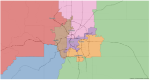
I agree with PH about splitting counties, though I don't think it's possible to completely avoid and we have split counties right now. For example, Eagle's split into east and west right now, and this map would tear down that Wall. What I like about this map at first glance is the districts mostly seem about as compact as you can realistically make 8 districts in a state the size of Colorado, with its core population in the central urban areas. No hydra-shaped Elbridge Gerry-inspired monstrosities, though the Denver district probably has to be that strange shape because of the DIA annexation.
This is far off from what the commission wants. I think the goal is pretty clearly that only the four big Denver counties are split. I think you can draw a map with Boulder, Larimer, Weld, El Paso and DougCo completely in tact, maybe even JeffCo (though that would create other problems.) Let alone smaller counties like Eagle.
Looks like a big part of Jefferson County would go into CO-03. That makes little sense.
JeffCo is already split between the CO-7 and the CO- 2. The chunk, south of I70 and west of C470, that might be split off to the CO-3 is large geographically but does not have much of a population base.
I mostly agree with you, but do keep in mind that JeffCo is a pretty mountain-focused area in the rural parts, which fits with CD3 a lot more than the San Luis valley.
Seems to me the only community of interest there is developers growing light industry and long the I25 corridor. Colorado Dems control everything in Colorado, and we're going to let developers "Texify" I25 north like they did I25 south? No thanks!
The biggest issue with this map is not only the large number of split counties, but the number of times some counties are split. Adams for example is in 4 different districts and Jeffco is in 3.
County splits are inevitable, but the new amendment to the Constitution makes minimizing them as a very high priority, right after numerical equality. I don’t think this map would hold up to Court approval.
I’m looking very forward to what the Commission staff presents later this month.
Also, they have El Paso County as one district. The population of the county is quite a bit larger than that of a CD so it will have to have part of its county in another district. The same with Denver.
That is true about Denver but not El Paso. El Paso has ~698k, and each district will have about ~701k. That's within the acceptable margin of deviance, at least according to the federal gov't.
How do you get to districts of 701k?
Colorado Census Population, Census, April 1, 2020 –5,773,714
Split evenly 8 ways, the districts would be 721,714.
Colorado Demography Office's most recent figures are for July 1, 2019:
Both are going to be close, perhaps with small carve-outs.
Actually we already have the OFFICIAL state total for Colorado for redistricting purposes: 5,782,171. Divide by 8 and each district is 722,771 or 722,772.
Using the CDO's numbers on the most recent post, will need to cut roughly 7k out of Denver and maybe 300 out of El Paso.
Of course we will have to wait until August to see the official number we need to use.
BTW, Ideal size for State Senate districts is now 165,204 or 5
and State House = 88,956 or 7
You are allowed to deviate up to 0.75% in total. (if you deviate 0.5% in one direction, you can deviate 0.25% in the other.)
Perfect equality would be completely impossible. Deviating by 300 is acceptable for a whole El Paso district.
Denver won't be "cut," more like trimmed. I think the Southwestern tip, which is slightly more conservative, will be lumped in with either district 8 or district 7. The DIA precinct will probably not be in D1 either.
I guess Dave's Redistricting is using outdated numbers. My B.
No wonder Republicans are freaking out about a gerrymander. This map splits Boulder and Weld, grouping towns like Frederick with Thornton, in order to give Democrats 5 districts. If you want a Hispanic district, what you should do is group Aurora with Thornton in district 6. But if you don't want to pack, then they won't have much influence in any district. Colorado just isn't laid out that way. Clearly, what we have here is a map that doesn't follow the requirements of Y/Z and instead tries to approximate the state's lean. Drawing the lines based on the result is a gerrymander.